


- 7:00 h
- 23.46 km
- 928 m
- 821 m
- 1,889 m
- 2,483 m
- 594 m
- Start: Gspon
- Destination: Simplonpass
4th stage: in the company of the Eida.
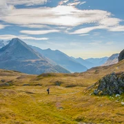
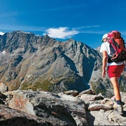
Continuing on this lookout path at an altitude of 2000 to 2300 meters, you reach the Gebidumpass, which is located above the town of Visperterminen. He is famous for his grapevines. Here is the basin, which is fed by an old canal, the "Biss", also called Eida. The Eida in turn carries the water of the Fletschhorn glacier. You now enter the Nanztal along the “Biss”, with a picturesque view of the valley and the steep face of the Fletschhorn. In Obers Fulmoos you walk on the other side of the valley and so you reach the Bistinenpass, from where you go into the Simplon Valley, with a view of Monte Leone (the highest mountain in the Lepontine Alps).

Good to know
Pavements
Best to visit
Directions
Equipment
Directions & Parking facilities
With the train to Stalden-Saas, with the gondola to Stalden-Ried and from there with the gondola to Gspon.
With the train to Stalden-Saas, with the gondola to Stalden-Ried and from there with the gondola to Gspon.
Additional information
Weitere Informationen finden Sie auf: www.simplon.ch
Safety guidelines
Nearby


