- 6:30 h
- 20.55 km
- 646 m
- 948 m
- 1,864 m
- 2,523 m
- 659 m
- Start: Almagelleralp
- Destination: Gspon
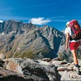
Stage 3: On the paths of the Walser.
From Almagelleralp, you ascend diagonally right out of the valley to reach a viewpoint overlooking Saas Fee and the Mischabel group. You pass through an area with avalanche protection facilities and, via the nature trail, reach Kreuzboden, the crucial point for the ascent to the "Trittico del Sempione" and the Weissmies, with a magnificent view of the 4000-meter peaks of the Saas valley. Then you continue on a wide path with small ascents and descents, pass small Walser settlements and ancient pastures, and finally reach Gspon.

Good to know
Pavements
Best to visit
Directions
Equipment
Directions & Parking facilities
Additional information
Further information can be found at: www.simplon.ch
Author´s Tip / Recommendation of the author
Safety guidelines
Nearby